Best Software for 2025 is now live!
Zu Meinen Listen hinzufügen
Nicht beansprucht
Nicht beansprucht

Top-bewertete SAGA GIS Alternativen

SAGA GIS Bewertungen & Produktdetails

SAGA GIS Übersicht

Was ist SAGA GIS?

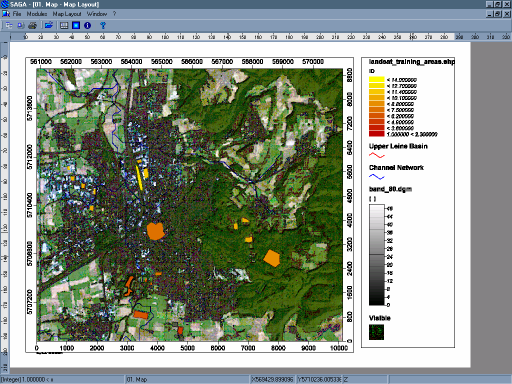
SAGA ist die Abkürzung für System für Automatisierte Geowissenschaftliche Analysen. SAGA bietet eine leicht zugängliche Benutzeroberfläche mit vielen Visualisierungsoptionen.

SAGA GIS Details
Diskussionen
SAGA GIS Community
Weniger anzeigenMehr anzeigen
Produktbeschreibung

SAGA ist die Abkürzung für System für Automatisierte Geowissenschaftliche Analysen. SAGA bietet eine leicht zugängliche Benutzeroberfläche mit vielen Visualisierungsoptionen.


Verkäuferdetails
Verkäufer
SAGA GIS
Hauptsitz
N/A

Aktuelle SAGA GIS Bewertungen

Amol S.
AS
Amol S.Kleinunternehmen (50 oder weniger Mitarbeiter)
4.5 von 5
"Gute Open-Source Geo-Analytics-Software"
Die Leichtigkeit, mit der man geospatiale Datenanalyse auf variablen Projektionssystemen durchführen kann und Daten mit einer sehr benutzerfreundli...
CHANCY S.
CS
CHANCY S.Unternehmen mittlerer Größe (51-1000 Mitarbeiter)
4.0 von 5
"Rezension zu SAGA GIS"
SAGA GIS ist eine Open-Source-Software, die für Geotechnologie verwendet wird. SAGA GIS verfügt über verschiedene einsatzbereite Werkzeuge wie Gelä...
Eunice S.
ES
Eunice S.Kleinunternehmen (50 oder weniger Mitarbeiter)
4.5 von 5
"Entwickeln Sie Ihr GIS-Projekt mit SAGA"
Die Anzahl der verfügbaren Funktionen ist enorm, Sie können Raster- und räumliche Informationen aus vielen Formaten verwenden, wie z.B. das gängige...
Sicherheitsabzeichen
Dieser Verkäufer hat seine Sicherheitsinformationen noch nicht hinzugefügt. Lassen Sie ihn wissen, dass Sie möchten, dass er sie hinzufügt.
0 Personen haben Sicherheitsinformationen angefordert

SAGA GIS Medien

SAGA GIS Demo - SAGA GIS
SAGA GIS
SAGA GIS Demo - SAGA GIS
SAGA GIS
SAGA GIS Demo - SAGA GIS
SAGA GIS
Beantworten Sie einige Fragen, um der SAGA GIS-Community zu helfen
Haben sie SAGA GIS schon einmal verwendet?
Ja

18 SAGA GIS Bewertungen

4.0 von 5
Die nächsten Elemente sind Filter und werden die angezeigten Ergebnisse ändern, sobald sie ausgewählt werden.
Bewertungen durchsuchen
Beliebte Erwähnungen
Die nächsten Elemente sind Radioelemente und sortieren die angezeigten Ergebnisse nach dem ausgewählten Element und aktualisieren die angezeigten Ergebnisse.
Filter ausblendenWeitere Filter
Die nächsten Elemente sind Filter und werden die angezeigten Ergebnisse ändern, sobald sie ausgewählt werden.
18 SAGA GIS Bewertungen
4.0 von 5
18 SAGA GIS Bewertungen
4.0 von 5

SAGA GIS Vor- und Nachteile

Wie wird diese bestimmt?Informationen
Vor- und Nachteile werden aus dem Feedback der Bewertungen zusammengestellt und in Themen gruppiert, um eine leicht verständliche Zusammenfassung der Benutzerbewertungen zu bieten.
Vorteile
Contra
G2-Bewertungen sind authentisch und verifiziert.
Verifizierter Benutzer in Financial Services
BF
Unternehmen(> 1000 Mitarbeiter)
Weitere Optionen
Bestätigter Bewerter
Bewertungsquelle: G2-Einladung
Anreizbasierte Bewertung
Was gefällt dir am besten SAGA GIS?

It provides the user an array of features like work with data from SQL, OBDC or Postgres and many other sources. Along with attributes and information can be added to the shapefiles.

Also with the abundance of formats compatibility, the cross platform work is easier to integrate. Few frequently used are raster, shapefiles, grid, DEM, tables etc. Bewertung gesammelt von und auf G2.com gehostet.

Was gefällt Ihnen nicht? SAGA GIS?

Interface & API needs serious upgrades, even for seasoned users.

E.g. every single element added to the workspace appears separately, so if one wants to edit an attribute table and watch the shapefile, we need to switch among a square to another to see the results. Bewertung gesammelt von und auf G2.com gehostet.

Empfehlungen an andere, die in Betracht ziehen SAGA GIS:

For organisations, where the requirement is to use only a free software to manage spatial data and a lot of information SAGA is for you, but you have to be aware remember this is a free software, so the interface and some processes can be a little niche. Bewertung gesammelt von und auf G2.com gehostet.

Was ist ein Problem? SAGA GIS Solving und wie profitieren Sie davon?

For our marketing campaigns with Banking for Cross selling and up selling, SAGA is used to develop a system of monitoring and evaluation to track our packages, check the routes and evaluate if we are doing the work in the right way.

To administer campaign data and outcomes with his kind of system, we make a link between spatial data and administration of supplies/source. Bewertung gesammelt von und auf G2.com gehostet.

Raghav S.
RS
Frontend Developer
Unternehmen mittlerer Größe(51-1000 Mitarbeiter)
Weitere Optionen
Bestätigter Bewerter
Bewertungsquelle: G2-Einladung
Anreizbasierte Bewertung
Übersetzt mit KI
Was gefällt dir am besten SAGA GIS?

Was mir an SAGA GIS wirklich gefallen hat, ist, dass es eine leicht zugängliche Benutzeroberfläche mit vielen Anzeigeoptionen bietet und zusammen mit anderen GIS-Programmen wie Kosmos verwendet werden kann, um bessere Vektor- und Kartendaten zu erhalten. Es bietet eine breite, wachsende Palette geowissenschaftlicher Methoden. Bewertung gesammelt von und auf G2.com gehostet.

Was gefällt Ihnen nicht? SAGA GIS?

Es dauert, weil wir, wenn wir anfangen, diese Software zu nutzen, viel tun müssen, wie zum Beispiel viele Formulare ausfüllen, bevor wir sie verwenden können. Bewertung gesammelt von und auf G2.com gehostet.

Was ist ein Problem? SAGA GIS Solving und wie profitieren Sie davon?

Ich habe einige NMT mit diesem Werkzeug erstellt, und es hilft uns, verschiedene Datenformate zu analysieren. Bewertung gesammelt von und auf G2.com gehostet.

Verifizierter Benutzer in Law Practice
BL
Kleinunternehmen(50 oder weniger Mitarbeiter)
Weitere Optionen
Bestätigter Bewerter
Bewertungsquelle: Verkäufer einladen
Was gefällt dir am besten SAGA GIS?

I liked that our firm no longer had to keep paper copy folders- for the most part. There were very few likes that I had about the software Bewertung gesammelt von und auf G2.com gehostet.

Was gefällt Ihnen nicht? SAGA GIS?

When we first got the software- we were glad to be helping the environment (in a sense) however over time we realized that this software wasnt ideal.. We still had to keep the files. It great to have paper copies.. but there was no point in the software, other than to use it as a reminder system. We eventually swithced over to Needles. The software would slow down the computers- causing them to freeze. sometimes we lost data. We still kept what was in SAGA- in SAGA--- but when going back for records-- it was very difficult. Bewertung gesammelt von und auf G2.com gehostet.

Empfehlungen an andere, die in Betracht ziehen SAGA GIS:

Update the system. Add more options. Make it more appealing. Implement something that will speed up the software so it doesnt crash. Bewertung gesammelt von und auf G2.com gehostet.

Was ist ein Problem? SAGA GIS Solving und wie profitieren Sie davon?

There were very few things that this software solved. SLIGHTLY less paper work. Bewertung gesammelt von und auf G2.com gehostet.

NM
Proyect Management
Unternehmen mittlerer Größe(51-1000 Mitarbeiter)
Weitere Optionen
Bestätigter Bewerter
Bewertungsquelle: G2-Einladung
Anreizbasierte Bewertung
Übersetzt mit KI
Was gefällt dir am besten SAGA GIS?

ermöglicht den Erhalt aktualisierter geografischer Informationen, verfügt über eine grafische Benutzeroberfläche, die Visualisierungen in Echtzeit ermöglicht Bewertung gesammelt von und auf G2.com gehostet.

Was gefällt Ihnen nicht? SAGA GIS?

Es ist teuer, da es hauptsächlich für wissenschaftliche Projekte entwickelt wurde. Bewertung gesammelt von und auf G2.com gehostet.

Empfehlungen an andere, die in Betracht ziehen SAGA GIS:

Es verwenden Bewertung gesammelt von und auf G2.com gehostet.

Was ist ein Problem? SAGA GIS Solving und wie profitieren Sie davon?

wir verwenden es in unseren Projekten für kartografische Projektionen, es ist ausgezeichnet und kompatibel mit Windows und Linux Bewertung gesammelt von und auf G2.com gehostet.

Verifizierter Benutzer in Education Management
BE
Kleinunternehmen(50 oder weniger Mitarbeiter)
Weitere Optionen
Bestätigter Bewerter
Verifizierter aktueller Benutzer
Bewertungsquelle: Verkäufer einladen
Was gefällt dir am besten SAGA GIS?

Puede ser usado junto con otros programas de SIG como kosmos para obtener mejores datos vectoriales y de mapa con capacidad de producir. Ofrece una amplia, creciente conjunto de métodos geocientíficos. Proporciona una interfaz de usuario accesible fácilmente con muchas opciones de visualización.. Bewertung gesammelt von und auf G2.com gehostet.

Was gefällt Ihnen nicht? SAGA GIS?

Maybe Improve the interface a bit. That interface could be better Bewertung gesammelt von und auf G2.com gehostet.

Empfehlungen an andere, die in Betracht ziehen SAGA GIS:

You can work on improving this tool with its Programming in C ++ that allows you to develop your own modules or modify your API according to your needs. Bewertung gesammelt von und auf G2.com gehostet.

Was ist ein Problem? SAGA GIS Solving und wie profitieren Sie davon?

Although it is not very easy to use, SAGA has a command line that has the advantage that it can be executed from batch process scripts, very useful .. Bewertung gesammelt von und auf G2.com gehostet.

Verifizierter Benutzer in Research
BR
Unternehmen mittlerer Größe(51-1000 Mitarbeiter)
Weitere Optionen
Bestätigter Bewerter
Verifizierter aktueller Benutzer
Bewertungsquelle: G2-Einladung
Anreizbasierte Bewertung
Was gefällt dir am besten SAGA GIS?

SAGA is an open source tool, designed to load vector objects or trace points, lines, polygons and manipulate them by simple or complex analysis methods, these can be liquid flow simulations, motivated by rain, ocean currents, evaporation and others. Other models that can be cited as the simulation of particle erosion, maximum entropy, the management of photogrammetric composition of remote sensing images

SAGA includes within its models, the concepts developed by Morgan, Finney, Duzant, Burrough, Hugget, among other professionals dedicated to quantitative geography.

SAGA saves equipment resources focusing its effort on data processing and not on visualization with a high level of aesthetics, allows QGIS to be used as a visualizer of the results of the processes and allows the user the possibility of obtaining a product . Graphic printing of higher quality.

SAGA can be compared with Esri Arc ToolBOX, since it presents the same performance with very similar results. Bewertung gesammelt von und auf G2.com gehostet.

Was gefällt Ihnen nicht? SAGA GIS?

It is a bit cumbersome to show the representations of the obtained processes, the creation of the print design and other attributes of a final map; I think that to have a print quality map, the results are better handled with other compatible software such as QGIS or GVSIG, which have developed more those processes.

I consider that it is necessary to devote a little more to the development of the data loading interface, explanation of the method and other things that contribute to the learning of new users Bewertung gesammelt von und auf G2.com gehostet.

Empfehlungen an andere, die in Betracht ziehen SAGA GIS:

The users must handle very well the concepts of each one of the methods of analysis of the plot included in the software, which variables should be handled, the projection of spatial data. All this so that they do not present problems with the obtained results or translate bad interpretations of the results.

I carried out several practices with LDD and Pattern Analysis for the identification of land with few threats due to extraordinary events of rain in the city of Barcelona, ​​Venezuela, whose results were satisfactory. Bewertung gesammelt von und auf G2.com gehostet.

Was ist ein Problem? SAGA GIS Solving und wie profitieren Sie davon?

The greatest contribution that SAGA offers us is the application of complex analysis methods of localized data for free, it facilitates geoscience researchers, who do not have high budgets for their research, operate software with a high level of complexity without cost, The tool is fed with the findings that these scientists can launch in the future and share with the developers to create a new version of an existing or completely new analysis method, in a human environment practically free of cost. Bewertung gesammelt von und auf G2.com gehostet.

Grzegorz N.
GN
geolog
Kleinunternehmen(50 oder weniger Mitarbeiter)
Weitere Optionen
Bestätigter Bewerter
Bewertungsquelle: G2-Einladung
Anreizbasierte Bewertung
Übersetzt mit KI
Was gefällt dir am besten SAGA GIS?

SAGA GIS ist eine kostenlose Software mit vielen Werkzeugen.

Ich kann viele Datenformate verwenden.

Dies ist ein gutes Werkzeug, um NMT zu erstellen.

Man kann Flächen- und Satellitenbilder analysieren. Bewertung gesammelt von und auf G2.com gehostet.

Was gefällt Ihnen nicht? SAGA GIS?

Wenn Sie diese Software verwenden, müssen Sie viele Formulare ausfüllen.

SAGA GIS verwendet zu viele Fenster. Bewertung gesammelt von und auf G2.com gehostet.

Empfehlungen an andere, die in Betracht ziehen SAGA GIS:

Dies ist professionelle, kostenlose GIS-Software.

Das SAGA GIS-Programm ist hervorragend für die Verbesserung räumlicher Daten. Bewertung gesammelt von und auf G2.com gehostet.

Was ist ein Problem? SAGA GIS Solving und wie profitieren Sie davon?

Ich benutze SAGA GIS, um LiDAR-Daten zu verbessern und zu analysieren. SAGA GIS ermöglicht die Analyse von Daten aus verschiedenen Quellen und in unterschiedlichen Formaten. Bewertung gesammelt von und auf G2.com gehostet.

Verifizierter Benutzer in Higher Education
BH
Unternehmen(> 1000 Mitarbeiter)
Weitere Optionen
Bestätigter Bewerter
Bewertungsquelle: G2-Einladung
Anreizbasierte Bewertung
Was gefällt dir am besten SAGA GIS?

It's functional and useful (and open source!) GIS software. I find it intuitive and fairly well supported. I appreciate SAGA's ability to interface with other open source software including R, and it is a major part of my goal to use mostly open source software. Bewertung gesammelt von und auf G2.com gehostet.

Was gefällt Ihnen nicht? SAGA GIS?

Online 3rd party support (via message boards, tutorials etc.) not as good as ArcGIS, and Google Earth Engine is quickly replacing everything as the best GIS software (plus it's free). Bewertung gesammelt von und auf G2.com gehostet.

Empfehlungen an andere, die in Betracht ziehen SAGA GIS:

Unfortunately for SAGA GIS, it and other GIS software are quickly being supplanted by Google Earth Engine, which is a more powerful and intuitive GIS tool. I recommend learning GEE instead of SAGA or ArcGIS. Bewertung gesammelt von und auf G2.com gehostet.

Was ist ein Problem? SAGA GIS Solving und wie profitieren Sie davon?

I use this software to make maps and to do basic GIS analysis. I have realized benefits including good, high quality images for professional publications, and information that has allowed me to progress projects that I'm working on. Bewertung gesammelt von und auf G2.com gehostet.